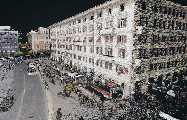
On the eve of CES 2022, which takes place January 5-8 in Las Vegas, HERE Technologies announced the availability of HERE Lidar Data, its global library of 3D Lidar (Light Detection and Ranging) data, on the HERE platform. It will enable the creation of a digital twin using Lidar data that offers powerful 3D modeling capabilities.
Lidar data
Laser measurement is the foundation of digital twin technology and high definition mapping applications.
Lidar (Light Detection And Ranging) is an optical remote sensing technique that uses laser light for dense sampling of the Earth’s surface. Whether on land or in an airplane, Lidar is based on the same acquisition process: a scanner, whose position and orientation are continuously measured, emits high-frequency infrared laser pulses towards an object or the ground. The calculation of the time elapsed between the emission of these pulses and their return to the emitter allows the deduction of the position of the impacted points. With several hundred thousand pulses emitted per second, the device quickly generates a large quantity of georeferenced points. The data is then processed to create 3D models: digital terrain models (altimetric description of the ground)…
HERE Lidar Data
HERE is a publisher of route planning and online mapping software. It offers the GPS application “Here we go”. Thanks to HERE Lidar Data, it is now possible to create a digital twin of reality by capturing millions of kilometers of road across more than 50 countries, with an accuracy of +/- 2 centimeters.
HERE Lidar Data has many applications in the public and private sectors:
- Public transportation organizations and agencies can access high-precision geospatial data for infrastructure management, road network planning, and traffic analysis.
- Engineering, architecture, and design firms can benefit from additional data for site selection analysis and impact simulations, as HERE Lidar Data easily integrates with building information modeling (BIM) software.
- Energy and telecom companies can centrally manage their inventory of poles, antennas and cables. Lidar data can also be used to optimize the planning and design of 5G networks.
Translated from HERE Technologies publie HERE Lidar Data, bibliothèque mondiale de données


