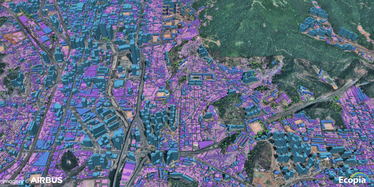
On March 4, 2021, Ecopia AI and Airbus announced a partnership to deliver next-generation digital maps on a global scale. On May 5, the two companies announced an expansion of this partnership that will produce a high-precision, three-dimensional vector representation of the real world, created and maintained at unprecedented speed. This expanded relationship will allow Ecopia to join the Airbus certified reseller network and thus resell Airbus imagery as part of its product line.
ECOPIA AI
Ecopia’s core technology was developed as a result of doctoral research at the University of Waterloo in Ontario, a leading institution in the field of innovation. Co-founded in 2013 by Yuanming Shu and two other UW graduates, Jon Lipinski and Shu Tan, the company specializes in extracting information from geospatial megadata. It leverages next-generation AI to convert high-resolution images of the Earth into HD vector maps that are integrated into mission-critical applications around the world. Its customers include governments, industry, NGOs, insurers…
In 2021, it opened a partnership that, among other things, gives it access to Airbus’ global database of 50 cm high-resolution imagery. The latter has been a leader in innovation and development in geospatial technologies and defense solutions for some 30 years, including the design of the Pleiades Neo satellites.
The Pleiades Neo constellation
Pleiades Neo, an optical constellation of four identical 30cm resolution satellites financed, manufactured and operated by Aibus, represents a real breakthrough in the field of Earth observation. The first launches took place in 2021, and the satellites put into orbit by Vega launchers at the Guiana Space Center will be complete this year.
The Pleiades Neo satellites are equipped with a new-generation lightweight silicon carburetor optical instrument and thanks to their inter-satellite links with the Airbus SpaceDataHighway (EDRS) geostationary spacecraft can enable urgent acquisitions as little as 40 minutes after a request.
They join Airbus’ two first-generation Pleiades spacecraft Pleiades 1A and Pleiades 1B, launched into orbit in 2011 and 2012, respectively, which provide 50-cm resolution images.
Extending the Ecopia AI and Airbus partnership
The expanded partnership will allow Ecopia to leverage the very high resolution 30 cm global imagery from Pleiades Neo and 50 cm from Airbus’ Pleiades, which will serve as an input for its AI-based 3D mapping systems. These 3D maps will provide a digital foundation for government, insurance, telecommunications and consumer applications.
François Lombard, director of Intelligence at Airbus Defence and Space, said:
“We are pleased to provide our very high resolution imagery to support Ecopia’s global 3D mapping capability. Pleiades Neo’s 30 cm resolution and geolocation accuracy, combined with Ecopia’s AI-based systems, provide the perfect assets for accurate and detailed mapping, while the high revisit frequency of the satellites is ideal for tracking land cover changes and maintaining any 3D database.”
Ecopia AI has begun large-scale map production as part of the partnership and has completed 3D vector mapping of buildings and vegetation in two countries, covering more than 14,000,000 buildings over 136,000 km2, in just 3 weeks.
Abigail Coholic, Senior Director of Channel Partnerships at Ecopia AI, states:
“We are very pleased to announce this extension of the Ecopia-Airbus partnership. This relationship not only strengthens Ecopia’s ability to provide high accuracy 3D vector maps on a global scale, but also represents a step towards our vision of creating a digital twin of the Earth in collaboration with our partners.”
.
Translated from Ecopia AI et Airbus annoncent une extension de leur partenariat pour fournir des cartes vectorielles 3D mondiale


